Synopsis:
Areas of light freezing rain, sleet and snow this evening will taper off. There will be a hard freeze tonight under clearing skies. Any standing water will become ice. Use caution.
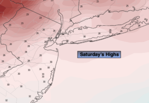
Saturday will feature another bitter blast with readings below freezing. At least the sun will be shining as Arctic high pressure dominates.
On Sunday, readings in urban areas may crack freezing with a mix of sun and clouds as high pressure begins to move off the coast.
Monday will be quite pleasant for early February with readings near 40º under bright skies.
A storm will be to our South on Tuesday and should not affect the region. Partly sunny skies are expected with readings a few degrees above the average high of 40º.
Bright and tranquil conditions are expected for Wednesday as weak high pressure dominates.
Stay tuned.
Tonight:
Areas of light freezing rain, sleet and snow this evening will taper off. Clearing and turning much colder. Lows in the teens to around 20º in urban areas. North/Northwest winds increasing to 10-20mph.
Saturday:
Mostly sunny, breezy and much colder. Highs in the upper 20s. Northwest winds at 15-25mph.
Sunday:
Partly sunny. Highs in the lower 30s.
Monday:
Partly sunny. Highs in the lower 40s.
Tuesday:
Partly sunny. Highs in the lower 40s.
Wednesday:
Mostly sunny. Highs in the lower to mid 40s.