Synopsis:
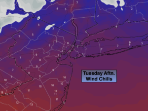
An Arctic blast will grip the region the next 24 hours. Readings today may remain in the teens. The wind will add a bite. Wind chills will be in the single digits and lower teens this afternoon. High pressure originating in Canada is responsible for our bitter bite. At least the sun will shine!
Clear, calm and very cold conditions are expected overnight.
By Wednesday, readings will pop to near the average high of the upper 30s.
Temperatures will recover on Thursday as high pressure slips offshore and the airmass modifies.
Cold conditions will return for Friday as low pressure moves well off the Eastern seaboard and a strong Northerly wind ushers in Canadian air once again.
Plenty of sun is expected for Saturday. Despite the sun, readings will only remain in the 20s!
We’ll keep an eye on a Southern Storm for Sunday. As of this writing it looks to stay off the coast
Stay tuned..
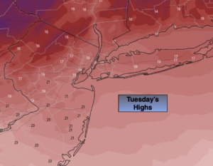
Tuesday:
Sunny and frigid. Highs only in the upper teens. Northwest winds at 15-25mph and diminishing.
Tonight:
Clear. Frigid. Lows in the upper teens in the City, single digits inland. Southwest winds at 5-10mph.
Wednesday:
Mostly sunny. Seasonal. Highs in the upper 30s.
Thursday:
Mostly sunny. Highs around 40º.
Friday:
Mostly sunny, windy and colder. Highs in the lower to mid 30s.
Saturday:
Sunny. Very cold. Highs in the upper 20s.