Synopsis:
Friday will feature a mixed sky with the Spring fling continuing for one more day. Highs will be close to fifteen degrees above average. Yes, we are saving some coin on the utility bill!
Clouds will roll in tonight ahead of the next system coming in from the South and West.
A rainy Saturday is on the way as low pressure from the Southwest approaches. It just maybe cold enough for a bit of mixed rain, snow and sleet North and West of the City. This shouldn’t amount to much. The rain should taper off during the afternoon.
It’ll be back to reality for Sunday and Monday with the sun returning as high pressure moves in from Canada. Temperatures by Monday may not get out of the upper 30s.
A seasonal Tuesday is expected with abundant sunshine as high pressure sits over the region.
Stay tuned..
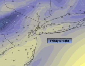
Friday:
Partly sunny. Warm. Highs in the upper 50s to lower 60s. West winds at 8-15mph.
Tonight:
Increasing clouds. Colder then recent nights. Lows in the upper 30s along the coast, near freezing well inland. West to Northeast winds at 5mph.
Saturday:
Cloudy with rain. Wet snow and sleet mixed with the rain North and West. The rain will taper off during the afternoon. Highs in the mid 40s.
Sunday:
Mostly sunny. Cooler. Highs in the lower to mid 40s.
Monday:
Sunny. Chilly. Highs in the upper 30s.
Tuesday:
Sunny. Seasonal. Highs in the mid 40s.