Synopsis:
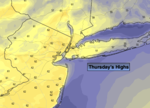
Morning clouds will give way to partly sunny skies today. Temperatures will pop to Spring-like readings as a deep Southerly flow of warm air streams in around a Western Atlantic high. Records will be challenged. The record high for Central Park is 63º set in 1971 and that reading is the forecast high for today.
A weakening cool front will approach tonight. Temperatures will remain well above average and be almost eight degrees above the average high of 45º!
Friday will feature a mixed sky with the Spring fling continuing.
A rainy Saturday is on the way as low pressure from the Southwest approaches.
It’ll be back to reality for Sunday and Monday with the sun returning as high pressure moves in from Canada. Temperatures by Monday may not get out of the upper 30s.
Stay tuned..
Thursday:
Clouds to some sun. Warm. Highs in the lower to mid 60s. Southwest winds at 10-15mph.
Tonight:
Partly cloudy. Very mild. Lows in the lower 50s along the coast, the 40s inland. Southeast to Southwest to West winds at 5-10mph.
Friday:
Partly sunny. Warm. Highs in the lower 60s.
Saturday:
Cloudy with rain. Highs in the mid 40s.
Sunday:
Mostly sunny. Cooler. Highs in the lower to mid 40s.
Monday:
Sunny. Chilly. Highs in the upper 30s.