Synopsis:
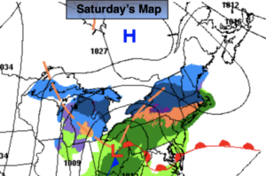
It will be a damp Saturday as low pressure from the Southwest approaches. Scattered showers are in the forecast. The best chance for a steadier rain will be in the morning. Many areas will have extended dry times during the afternoon. It just maybe cold enough for a bit of sleet mixed in well North of the City. This shouldn’t amount to much.
Scattered showers will continue tonight as the front pushes offshore.
It’ll be back to reality for Sunday and Monday with the sun returning as high pressure moves in from Canada. Temperatures by Monday may not get out of the upper 30s.
Winter’s arrival on Tuesday will be a seasonal one. Abundant sunshine is expected as high pressure sits over the region. Not much will change for Wednesday.
At this time the chances of a white Christmas look slim.
Stay tuned..
Saturday:
Cloudy with scattered showers. sleet may mix in well North. The afternoon will have extended dry periods. Highs in the mid to upper 40s. Northeast to East winds at 5-10mph.
Tonight:
Scattered showers. Lows in the upper 30s along the coast, near freezing well inland. Winds becoming Northwest at 10-15mph.
Sunday:
Mostly sunny. Cooler. Highs in the lower to mid 40s.
Monday:
Sunny. Chilly. Highs in the upper 30s.
Tuesday:
Sunny. Seasonal. Highs in the mid 40s.
Wednesday:
Sunny. Highs in the lower to mid 40s.