Synopsis:
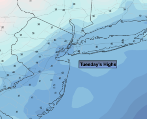
Much colder conditions are expected for Tuesday with high pressure moving in from the North. Readings will be almost twenty degrees colder than Monday’s highs. Skies will be mainly sunny.
Clouds will roll in tonight ahead of the next system moving in from the Southwest.
On Wednesday, a developing area of low pressure will move far enough off the coast to spare the region of a widespread rain or snow event. Scattered snow showers area possible, but nothing major is expected. Rain showers will most likely fall at the coast.
A cool bright day is on the way for Thursday as high pressure moves in.
Milder conditions are expected on Friday as a Southerly wind develops around seaward areas of high pressure.
Balmy conditions are expected for Saturday as a deep Southerly flow develops ahead of an approaching cold front. Scattered showers are possible just about anytime, but it doesn’t look like a washout.
Stay tuned..
Tuesday:
Mostly sunny. Much colder. Highs in the lower 40s. West to Northwest winds at 5-10mph.
Tonight:
Increasing clouds. Lows in the lower 30s in the City, the 20s inland. Northwest to Northeast winds under 5mph.
Wednesday:
Scattered snow showers possible. Rain showers are the coast. Highs in the upper 30s.
Thursday:
Sunny and cold. Highs in the upper 30s.
Friday:
Mostly cloudy with spotty showers. Milder. Highs around 50º.
Saturday:
Balmy with scattered showers. Highs in the lower 60s.