Synopsis:
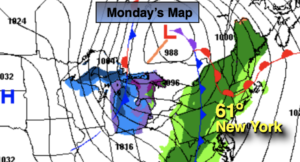
Ahead of a cold front today it will be balmy. Spotty showers are possible in the morning and then again in the evening. Readings will pop to near 60º with a gusty South wind.
Showers this evening will give way to clearing skies. It’ll be windy and colder.
Much colder conditions are expected for Tuesday as high pressure moves in from the North. Readings will be almost twenty degrees lower than Monday’s highs. Skies will be mainly sunny.
On Wednesday, the computer models have now taken the developing area of low pressure off the coast far enough to spare the region of a widespread rain or snow event. Scattered snow showers area likely, but nothing major is expected. Could there be a coating in spots? Yes.
Behind the departing system on Thursday skies will be sunny and a brisk, cold wind will prevail.
Milder conditions are expected on Friday with a few showers as another cool front approaches.
You know where to find a no hype, no nonsense forecast.
Stay tuned..
Monday:
Mostly cloudy. Balmy and breezy. Spotty showers. Highs around 60º. South to Southwest winds at 15-25mph with gusts to 30mph.
Tonight:
Showers early, otherwise clearing skies. Windy and turning colder. Lows in the mid 30s in the City, the 20s inland. Northwest winds at 15-30mph with gusts to 40mph.
Tuesday:
Mostly sunny. Much colder. Highs in the lower 40s.
Wednesday:
Scattered snow showers possible. Highs in the upper 30s.
Thursday:
Sunny and cold. Highs in the upper 30s.
Friday:
Mostly cloudy with spotty showers. Milder. Highs around 50º.