Synopsis:
A developing area of low pressure will move far enough off the coast to spare the region of a widespread rain or snow event today. Isolated flurries or showers area possible, but nothing major is expected.
Skies will clear tonight as the system moves out into the Atlantic.
A cool bright day is on the way for Thursday as high pressure moves in.
Milder conditions are expected on Friday as a Southerly wind develops around seaward areas of high pressure.
Saturday will be balmy as a deep Southerly flow develops ahead of an approaching cold front. Scattered showers are possible just about anytime, but it doesn’t look like a washout.
The sun will return for Sunday. Temperatures will be tolerable for mid December.
Stay tuned..
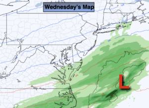
Wednesday:
Mostly cloudy with isolated flurries or showers. Highs in the upper 30s to lower 40s. North to Northeast winds at 5-10mph.
Tonight:
Clearing skies. Cold. Lows in the lower 30s in the City, the 20s inland. Northwest winds at 10-15mph.
Thursday:
Sunny. Chilly. Highs around 40º.
Friday:
Mostly cloudy with spotty afternoon showers. Milder. Highs around 50º.
Saturday:
Balmy with scattered showers. Highs in the mid 60s.
Sunday:
Mostly sunny. Highs in the upper 40s.