Synopsis:
The coolest air of the young fall season so far will move in today and stick around through the end of the week as we welcome October. A Canadian airmass will make a visit. The sun will dominate through Friday. Readings will be several degrees below the average high of 72º. Overnight lows will be chilly.
Seasonal sunshine will start off our weekend as high pressure moves offshore. By Sunday, a cool front will approach with sun giving way to possible afternoon showers.
Keep it here for a no hype-no nonsense forecast.
Stay tuned.
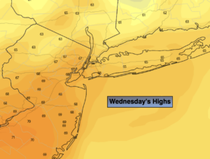
Wednesday:
Mostly sunny. Highs in the upper 60s. Northwest winds at 10-15mph.
Tonight:
Clear and chilly. Lows in the mid 50s in the City, the 40s inland. Northwest winds at 5mph.
Thursday:
Mostly sunny. Cool. Highs in the mid 60s.
Friday:
Sunny. Highs in the mid to upper 60s.
Saturday:
Sunny. Highs in the lower 70s.
Sunday:
Early sun will give way to possible afternoon showers. Highs in the lower 70s.