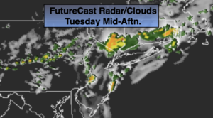
Synopsis:
A cool front will move through the region today. More clouds than sun is expected with scattered showers. Spotty storms are possible later in the day with the front. Readings will be just above the average high of 72º.
Any showers and evening spotty storms will end, otherwise skies will become mostly clear tonight.
The coolest air of the young fall season so far will move in on Wednesday and stick around through the end of the week as we welcome October. A Canadian airmass will make a visit. Start gathering up that firewood!
Seasonal sunshine will start off our weekend.
Keep it here for a no hype-no nonsense forecast.
Stay tuned.
Tuesday:
More clouds than sun. Scattered showers. Spotty PM storms. Highs in the mid 70s. West to Northwest winds at 5-10mph.
Tonight:
An evening shower or storm, otherwise becoming mostly clear. Much cooler. Lows in the mid 50s in the City, the 40s inland. Northwest winds at 8-12mph.
Wednesday:
Mostly sunny. Highs in the upper 60s.
Thursday:
Partly sunny. Cool. Highs in the mid 60s.
Friday:
Sunny. Highs in the upper 60s.
Saturday:
Sunny. Highs in the lower 70s.