Synopsis:
Today will be a fall classic. Under abundant sunshine readings will warm several degrees above the average high of the low 70s. A southwest flow around the high will be responsible for our mild readings.
A cool front will move through the region Tuesday. More clouds than sun is expected with scattered showers.
The coolest air of the young fall season so far will move in on Wednesday and stick around to the end of the week as we welcome October. A Canadian airmass will make a visit. Start gathering up that firewood!
Keep it here for a no hype-no nonsense forecast.
Stay tuned.
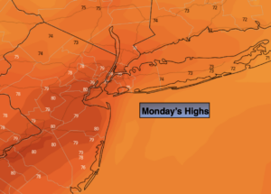
Monday:
Mostly sunny. Warmer and breezy. Highs in the upper 70s. West to Southwest winds at 10-20mph with higher gusts.
Tonight:
Mostly cloudy. Not as cool as recent nights. Lows in the mid 60s in the City, the 50s inland. Southwest winds diminishing at 5-10mph.
Tuesday:
More clouds than sun. Scattered showers. Highs in the mid 70s.
Wednesday:
Mostly sunny. Cooler. Highs in the upper 60s.
Thursday:
Partly sunny. Cool. Highs in the mid 60s.
Friday:
Sunny. Highs in the upper 60s.