Synopsis:
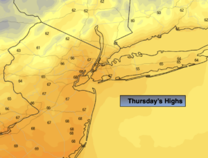
High pressure moving in from Southeastern Canada will provide the region with a cool September finale. A mix of sun and clouds is expected with readings several degrees below the average high of 71º.
Tonight will be the coolest night of the season so far with readings well North and West plummeting into the lower 40s!
Friday will be defined as a Fall Classic. Abundant sunshine and a crisp feel will greet us for October’s debut.
The first weekend of the new month will be a winner as high pressure sits offshore. Mainly sunny skies are anticipated with temperatures moderating temperatures. It will be warm by Sunday with some areas approaching 80º.
By Monday, a cool front will approach with sun giving way to possible afternoon showers. It’ll still be warm.
Keep it here for a no hype-no nonsense forecast.
Stay tuned.
Thursday:
Partly sunny. Cool. Highs in the mid 60s. Northwest winds at 8-12mph.
Tonight:
Clear and chilly. Lows in the lower 50s in the City, the 40s inland. Northwest winds at 5mph.
Friday:
Sunny. Highs in the mid to upper 60s.
Saturday:
Sunny. Highs in the lower 70s.
Sunday:
Mostly sunny. Warmer. Highs 75º-80º.
Monday:
Sun and clouds. Showers possible. Highs in the mid to upper 70s.