Synopsis:
High pressure over the Western Atlantic will be basically stationary for the next several days. This will result in increasing heat and humidity.
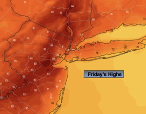
Today’s sky condition will all depend on your location. Moisture around the area of high pressure will be trapped along coastal locations. This will result in cloudy skies. The sun will return as the day goes on in these regions. Farther to the West, the sun will dominate. Readings will be near the seasonal levels of the lower 80s. It will be cooler where the clouds persist along the coast.
Another round of clouds and even a few showers are possible in all locations tonight into Saturday morning. Once again due to the moisture laden flow off the Atlantic. Increasing sunshine is expected by Saturday afternoon. The humidity will increase dramatically.
Sunday should feature more sun as we heat up.
The 3 H’s will be with us for much of next week as a typical Summertime pattern continues with a persistent Southwest wind around Atlantic high pressure.
Stay tuned.
Keep it here for a no nonsense, no hype forecast.
Today:
Sunny West. Clouds to some sun along the coast. Highs in the lower 80s, cooler at the coast. Northeast to South winds at 5-10mph.
Tonight:
Mostly cloudy with spotty showers possible. Much milder than recent nights. Lows in the upper 60s in the City, near 60º inland. South winds at 5mph.
Saturday:
Clouds and a possible morning shower to hazy sun, more humid. Highs in the lower to mid 80s.
Sunday:
Hazy sun, very warm and humid. Highs in the upper 80s.
Monday:
Hazy, hot and humid. Highs around 90º.
Tuesday:
3 H’s. Highs in the lower 90s.