Synopsis:
High pressure over the Western Atlantic will be basically stationary for the next several days. This will result in increasing heat and humidity and most likely result in a heatwave next week.
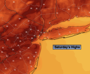
Today will start off with areas of clouds and fog, otherwise hazy sunshine is expected. You’ll notice an increase in humidity. An isolated storm is possible later in the day. Most areas will remain dry. Readings will be near seasonal levels (the lower to mid 80s).
Sunday will feature more of the same with many areas starting off with a grey start and a return of hazy sun during the day. It will be warmer with highs several degrees above average.
The 3 H’s will be with us for much of next week as a typical Summertime pattern continues with a persistent Southwest wind around Atlantic high pressure. This will result in a heatwave.
Stay tuned.
Keep it here for a no nonsense, no hype forecast.
Today:
Areas of morning clouds giving way to hazy sunshine, more humid. An isolated late day storm is possible. Highs in the lower to mid 80s. Cooler at the coast. South winds at 8-15mph.
Tonight:
Mostly cloudy with patchy fog. Warm. Lows in the lower to mid 70s in the City, the 60s inland. South winds at 5-10mph.
Sunday:
Hazy sun, very warm and humid. Highs in the upper 80s. Cooler at the coast.
Monday:
Hazy, hot and humid. Highs in the lower to mid 90s.
Tuesday:
3 H’s. Highs in the lower to mid 90s.
Wednesday:
3 H’s. Highs in the lower to mid 90s.