Synopsis:
High pressure over the Northeast will move off the coast through late week. Today’s conditions will once again be picture perfect with readings a few degrees below the average high of 82º.
Clouds and spotty showers are possible tonight into Friday morning mainly over coastal areas as a weak disturbance move in from the Southeast. The sun will dominate the sky during the afternoon.
By the weekend, the temperature and humidity will creep up as high pressure off the coast turns the wind to a more Southerly component. Both days may start off with mainly cloudy skies but hazy sun is expected by afternoon.
The 3 H’s will be with us for early next week as a typical Summertime pattern continues with a persistent South wind around the Atlantic high pressure.
Stay tuned.
Keep it here for a no nonsense, no hype forecast.
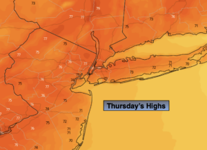
Today:
Sunny. Highs in the upper 70s. East winds at 8-12mph.
Tonight:
Mostly cloudy with spotty showers possible over coastal areas. Lows in the lower 60s in the City, the 50s inland. Northeast winds at 5mph.
Friday:
Clouds to sun. Slight chance of a morning showers East. Highs in the upper 70s.
Saturday:
Clouds to hazy sun, more humid. Highs in the lower to mid 80s.
Sunday:
Hazy sun, warm and humid. Highs in the upper 80s.
Monday:
Hazy, hot and humid. Highs around 90º.