
Synopsis:
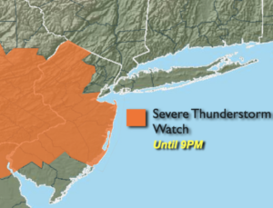
A Severe Thunderstorm Watch is in effect for much of NJ until 9PM. Scattered storms this evening have the potential to contain winds in excess of 58mph and or one inch hail. Frequent cloud to ground lighting and torrential rain is likely in some of the storms. Once the storms diminish overnight skies will become partly cloudy.
A mix of sun and clouds is expected for Tuesday. A spot shower is possible Tuesday afternoon as the last in a series of disturbances moves through.
High pressure will finally build into the region from the West for the rest of the week. Abundant sunshine and warm temperatures are anticipated.
Temperatures will heat up on Saturday as the winds turn to the Southwest. A spotty afternoon thunderstorm is possible in the building humidity.
Stay tuned.
Keep it here for a no nonsense, no hype forecast.
Tonight:
Scattered thunderstorms, some maybe severe. Becoming partly cloudy. Lows in the lower 60s in the City. The upper 50s to around 60º inland. Southeast winds at 5mph.
Tuesday:
Partly sunny. An isolated shower is possible in the afternoon. Highs in the upper 70s.
Wednesday:
Sunny. Highs around 80º.
Thursday:
Sunny. Highs around 80º.
Friday:
Mostly sunny. Warmer. Highs in the lower to mid 80s.
Saturday:
Hazy, warm and humid with scattered afternoon storms. Highs in the upper 80s.