Synopsis:
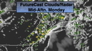
A weak disturbance will move across the region today-Flag Day. This will keep the threat of scattered showers and isolated storms in the forecast. It won’t be raining all of the time. Readings will be below average with the clouds and rain-cooled air. A few hours of rain is likely tonight.
A spot shower is possible Tuesday as the system moves offshore, otherwise a mix of clouds and sun is expected.
High pressure will finally build into the region from the West for the rest of the week. Abundant sunshine and warm temperatures are anticipated.
Stay tuned.
Keep it here for a no nonsense, no hype forecast.
Today:
Mostly cloudy with scattered showers and isolated storms. Highs in the lower 70s. Southeast winds at 5-10mph.
Tonight:
A period of rain. Lows in the lower 60s in the City. The upper 50s to around 60º inland. Southeast winds at 5mph.
Tuesday:
Partly sunny. An isolated shower is possible. Milder. Highs in the upper 70s.
Wednesday:
Sunny. Highs around 80º.
Thursday:
Sunny. Highs around 80º.
Friday:
Mostly sunny. Warmer. Highs in the lower to mid 80s.