Synopsis:
The first weekend of June will be sunny and hot as high pressure re-establishes itself off the Southeast coast and becomes a heat pump. Readings will be at least fifteen degrees above the average high of the mid 70s. Please slather on the sunscreen as the UV index will be a very high 9. Keep hydrated and try to stay in shaded areas.
The heatwave should continue into midweek Abundant sunshine is expected with increasing levels of humidity. Spotty late storms are possible Tuesday and Wednesday.
Stay tuned.
Keep it here for a no nonsense, no hype forecast.
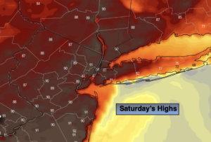
Today:
Sunny and hot. Highs in the lower 90s. Cooler over Eastern Long Island. West to Southwest winds at 10-15mph.
Tonight:
Clear. Warm in urban areas with readings in the lower to mid 70s. Lows in the 60s inland. West to Southwest winds at 5mph.
Sunday:
Sunny. Hot. Highs in the lower 90s.
Monday:
Hazy, hot and humid. Highs around 90º.
Tuesday:
3 H’s. Spotty PM Storm. Highs in the lower 90s.
Wednesday:
3 H’s. Spotty PM Storm. Highs around 90º.