Synopsis:
A Bermuda high will be responsible for our heat the next several days. Now, whether it’s an official heatwave (3 consecutive days of 90º+) for New York City remains to be seen. Many reporting stations will record a heatwave such as Newark and other urban areas. No matter how you slice it we’re in for some hot and humid weather. Hazy sun is expected through Wednesday. An afternoon and evening thunderstorm possibility is in the forecast for Tuesday and Wednesday.
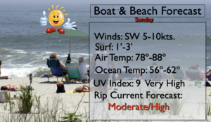
Please slather on the sunscreen as the UV index will be a very high 9 on Sunday. Keep hydrated and try to stay in shaded areas.
A cold front will pass through the region on Thursday. Scattered showers are possible, otherwise a mix of sun and clouds is expected.
Stay tuned.
Keep it here for a no nonsense, no hype forecast.
Today:
Sunny. Hot. Highs in the lower 90s. West to Southwest winds at 10-15mph.
Tonight:
Clear. Warm in urban areas with readings in the mid 70s. Lows in the 60s inland. Southwest winds at 5mph.
Monday:
Hazy, very warm and humid. Highs in the upper 80s to around 90º.
Tuesday:
Hazy, very warm and humid. Spotty PM Storm. Highs in the upper 80s to around 90º.
Wednesday:
Hazy, very warm and humid. Spotty PM Storm. Highs in the upper 80s to around 90º.
Thursday:
Sun and clouds. Cooler. Scattered showers possible. Highs in the lower 80s.