Synopsis:
High pressure over the Northeast will influence our weather today. Readings will still be quite warm but the humidity levels will be much lower. Many will be smiling about today’s forecast.
Cooler readings are expected for Friday with a wind off the Atlantic. An area of low pressure will give us some much needed rain by afternoon and night.
The Memorial Holiday Weekend is not looking like a beach weekend for 2 out of the 3 days. The offshore low pressure system will pull away on Saturday. It now looks to do this more slowly. What this means is that morning rain will taper off to scattered showers by afternoon. It will be unseasonably cool with readings ten to fifteen degrees below the average high of the mid 70s. A weak secondary area of low pressure may develop off the coast for Sunday. I had to go more pessimistic on the forecast. Mostly cloudy skies are now expected for Sunday with the chance of spotty showers. High pressure in Southeastern Canada should funnel in enough dry air for a decent Memorial Day Monday. Mainly sunny skies and more seasonal temperatures are anticipated. More times than not the forecast for the unofficial beginning of Summer (the holiday weekend) includes some threat of rain and cool temperatures. This year will be no different.
Stay tuned.
Keep it here for a no nonsense, no hype forecast.
Today:
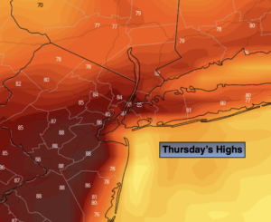
Mostly sunny, warm and much less humid. Highs in the lower to mid 80s. Northwest winds at 10-15mph.
Tonight:
Partly cloudy. Cooler. Lows in the upper 50s in the City, the upper 40s inland. Northwest to Northeast winds at 5mph.
Friday:
Mostly cloudy with the chance of afternoon rain. Much cooler. Highs in the mid 60s.
Saturday:
Morning rain, otherwise mostly cloudy with scattered showers. Very cool. Highs only around 60º.
Sunday:
Mainly cloudy. Spotty showers possible. Cool. Highs in the mid 60s.
Memorial Day:
Mostly sunny. More seasonal Highs in the lower to mid 70s.