Synopsis:
A front will push through during the morning. This system will increase the winds across the region. Temperatures will be near average (mid 60s). A storm will rapidly intensify over Eastern Canada. This will result in a greater increase in Northwesterly winds during the afternoon and night. Winds could gusts over 50mph by this evening.
May’s Debut is Saturday. A cooler push of Canadian air will arrive with readings actually just below normal. A mix of sun and clouds is expected with a gusty wind. Sunday will start off bright as high pressure dominates over the Southeastern part of the nation. A weak disturbance will move through in the afternoon with clouds and scattered showers (it will not be a washout).
The beginning of the week looks mild to warm under a mix of clouds and sun. Spotty showers are possible both Monday and Tuesday as low pressure disturbances continue to move through.
Stay tuned.
Keep it here for a no nonsense, no hype forecast
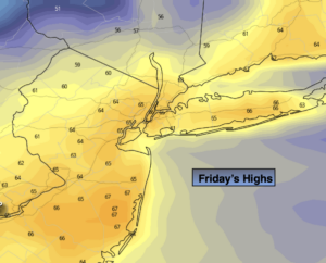
Today:
Sun and clouds.. Becoming windy. Highs in the mid to upper 60s. West to Northwest winds increasing to 15-30mph during the afternoon with gusts nearing 50mph by evening.
Tonight:
Clear and much colder. Lows in the lower to mid 40s in the City, the 30s inland. Northwest winds at 15-30mph with gusts to 50mph.
Saturday:
Partly sunny, breezy and seasonal. Highs in the mid 60s.
Sunday:
Partly sunny. Much Warmer. Spotty PM showers possible. Highs in the mid 70s.
Monday:
Partly sunny. Spot shower. Mild. Highs around 70º.
Tuesday:
Partly sunny. Spot shower. Warm. Highs in the upper 70s.