Synopsis:
It’ll be a bright and pleasant start to the weekend and the month of May. Winds will finally abate during the day as high pressure builds in from the Southeast. Temperatures will be just shy of the average high of the upper 60s.
A warm front will push through tonight with scattered showers.
A mix of sun and clouds is expected for Sunday. A warm Southwest wind will cause temperatures to pop to near 80º. It’ll cooler at the coast. An isolated shower is possible but much of the day will be dry.
A familiar forecast will be with us for the beginning to middle portion of the week. It’ll be mild to warm under a mix of clouds and sun. Spotty showers are possible just about anytime, but by no means will it be a washout as low pressure disturbances rapidly move through. The best chance of showers will be Wednesday with the passage of a cool front.
Stay tuned.
Keep it here for a no nonsense, no hype forecast
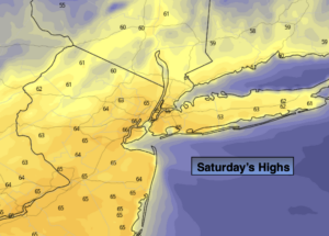
Today:
Mostly sunny and breezy. Highs in the mid 60s. Northwest to Wet winds diminishing to 10-15mph by afternoon.
Tonight:
Mostly cloudy with scattered showers. Lows in the mid 50s in the City, the 40s to lower 50s inland. Southwest wind at 5-10mph.
Sunday:
Partly sunny. Much Warmer. An isolated shower possible. Highs around 80º. Cooler at the coast.
Monday:
Partly sunny. Spot shower. Mild. Highs in the lower 70s.
Tuesday:
Partly sunny. Spot shower. Warm. Highs in the mid to upper 70s.
Wednesday:
Partly sunny. Scattered showers. Highs in the lower 70s.