Synopsis:
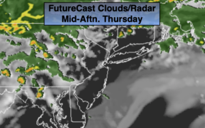
Today will be a changeable day. Scattered showers are likely during the morning. Then there will be a break and several hours of dry time and some sun. Another round of scattered showers will come our way later in the day and at night. This is all due to a very warm airmass just to our South and a lingering frontal boundary over our Northern areas. Temperatures today will be warm, especially South and West of the City. Readings will be well above the average of the mid to upper 60s. Temperatures will be cooler North and East of the City and along the immediate coast.
On Friday, the front will push through. An isolated shower is possible under partly cloudy skies. Temperatures will be near average. A storm will rapidly intensify over Eastern Canada. This will result in increasing strong Northwest wind during the afternoon and night. Winds could gusts over 50mph at this time.
May’s Debut is this weekend. A cooler push of Canadian air will arrive on Saturday with readings actually just below normal. A mix of sun and clouds is expected with a gusty wind. It will be a bright and warm Sunday as high pressure dominates.
Stay tuned.
Keep it here for a no nonsense, no hype forecast.
Today:
More clouds than sun. Warm. Scattered showers possible just about anytime. There will be an extended period of dry time during the midday hours. Highs in the 70s. Cooler at the coast. Southwest winds at 5-10mph.
Tonight:
Mostly cloudy with scattered showers. An isolated storm possible South. Lows in the 50s throughout. Southwest to West winds at 10-20mph.
Friday:
Sun and clouds. Cooler. Isolated showers possible. Becoming windy. Highs in the mid to upper 60s.
Saturday:
Partly sunny. Seasonal. Highs in the mid 60s.
Sunday:
Partly sunny. Much Warmer. Highs in the mid 70s.
Monday:
Partly sunny. Warm. Highs in the upper 70s.