Synopsis:
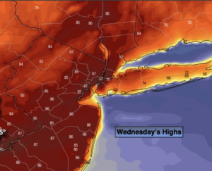
A Bermuda high will setup shop today. This system will be responsible for a Summer feel. Highs will reach July readings, minus the humidity. A mix of sun and clouds is expected. Temperatures should reach almost twenty degrees above the average high of 65º. The record high for Central Park is 90º set in 2009. This record should not be in jeopardy.
Scattered showers are likely tonight with a weak disturbance moving through.
Thursday forecast has been challenging to say the least. How warm will it get and how much in the way of showers will occur with an approaching cool front? I’ll continue to play the middle of the road here with a bit of a cool down from Wednesday Summery readings (it will still be very warm). Spotty showers will be left in the forecast for later in the day. A mix of sun and clouds is anticipated.
On Friday, the front will push through. An isolated shower is possible under partly cloudy skies. Temperatures will still be several degrees above the average highs of the mid 60s.
May’s Debut is the weekend. A cooler push of Canadian air will arrive on Saturday with readings actually just below normal. A mix of sun and clouds is expected with a gusty wind. It will be a bright and mild Sunday as high pressure dominates.
Stay tuned.
Keep it here for a no nonsense, no hype forecast.
Today:
Mostly sunny. Much warmer. Highs in the mid 80s. Cooler along the immediate coast and Long Island. Southwest winds at 5-10mph.
Tonight:
Mostly cloudy and warm. Scattered showers possible. Lows in the mid 60s in the City, the upper 50s to 60º inland. Light and variable winds.
Thursday:
More clouds than sun. Warm. Scattered showers possible just about anytime. Highs in the upper 70s. Cooler at the coast.
Friday:
Sun and clouds. Cooler. Isolated showers possible. Highs around 70º.
Saturday:
Partly sunny. Much cooler. Highs in the mid 60s.
Sunday:
Partly sunny. Mild. Highs around 70º.