Synopsis:
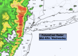
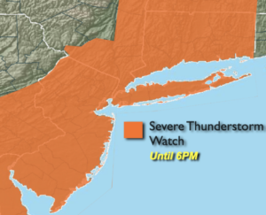
***Severe Thunderstorm Watch for the entire tri-state area until 6pm***Keep an eye to the sky for threatening weather. Severe thunderstorms contain winds in excess of 58mph and or large hail. Frequent lightning and torrential rain is possible in any of the storms.
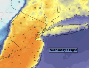
A cold front will approach today. Ahead of it warm readings can be expected (map above) under a mix of clouds and some sun. Spotty showers are possible just about anytime but much of the 1st half of the day will be dry. The sharp cold front will swing through the region during the mid to late afternoon. This time will be the best chance of a burst of rain and a few thunderstorms may occur. Readings will tumble by late day (as you can see the sharp contrast in color contours with the first map above). It will be chilly by dinnertime.
Tonight will quite cold for April. Readings inland will fall below freezing. In fact, a Freeze Warning has been issued for Northwestern NJ and parts of lower NY state. Please bring in any potted plants and protect tender vegetation.
Thursday will be windy and cooler behind the front under a mix of sun and clouds. Highs will be ten degrees below the average high of the lower 60s.
Temperatures will rebound on Friday to seasonal readings under partly sunny skies a high pressure builds in.
The weekend will start off pleasant with mild sunshine. Saturday will be the better half of the weekend. On Sunday a storm will form in Virginia coast and move Northeast. Rain is likely through early to mid afternoon.
Stay tuned.
Keep it here for a no nonsense, no hype forecast.
Today:
Clouds, some sun. Spotty showers. Quick moving line of heavier showers and possible storms mid to late afternoon. Highs in the mid 60s then temperatures will tumble late day. South winds becoming Northwest and increasing to 15-25mph with gusts to 35mph late day.
Tonight:
Partly cloudy, windy and much colder. Lows in the mid 30s in the City, the upper 20s to lower 30s inland. Northwest winds at 15-25mph with gusts to 35mph.
Thursday:
Partly sunny, windy and cooler. Highs in the lower 50s.
Friday:
Mostly sunny. Seasonal. Highs in the lower to mid 60s.
Saturday:
Partly sunny. Mild. Highs in the mid to upper 60s.
Sunday:
Rain likely. Cooler. Highs in the upper 50s..