Synopsis:
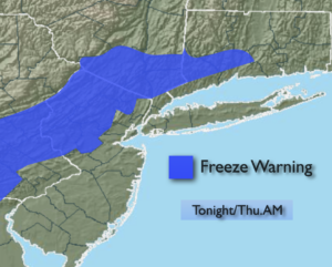
Tonight will quite cold for April. Readings inland will fall below freezing as an unseasonably cold airmass moves in from Canada. In fact, a Freeze Warning has been issued for Northwestern NJ and parts of lower NY state. Please bring in any potted plants and protect tender vegetation. Most areas along the coast will remain just above freezing, but the wind will make it feel like the 20s everywhere.
Thursday will be windy and cooler under a mix of sun and clouds. Highs will struggle to get to 50º.
Temperatures will rebound on Friday to seasonal readings under partly sunny skies a high pressure builds in.
The weekend will start off pleasant with mild sunshine. Saturday will be the better half of the weekend. On Sunday a storm will form in Virginia and move Northeast. Rain is likely through early to mid afternoon. Some late day sun is possible.
Stay tuned.
Keep it here for a no nonsense, no hype forecast.
Tonight:
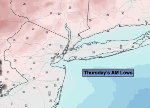
Partly cloudy, windy and much colder. Lows in the mid 30s in the City, the upper 20s to lower 30s inland. Northwest winds at 15-25mph with gusts to 35mph.
Thursday:
Partly sunny, windy and cooler. Highs in the 40s to around 50º. Northwest to West winds at 15-25mph with gusts to 35mph.
Friday:
Mostly sunny. Seasonal. Highs in the lower 60s.
Saturday:
Partly sunny. Mild. Highs in the mid to upper 60s.
Sunday:
Rain likely through early afternoon. Late day sun. Highs in the lower 60s.
Monday:
Mostly sunny. Highs in the lower to mid 60s.