Synopsis:
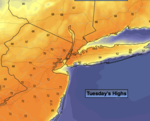
It will be a top ten Tuesday. Mainly sunny skies are expected with highs about ten degrees above the average of 62º. The warm sun will be welcomed by most!
On Wednesday, a cool front will approach. Spotty showers are likely under mostly cloudy skies. The best chance will be with the front by mid to late afternoon. A few thunderstorms may occur at this time.
Thursday will be breezy and cooler behind the front under a mix of sun and clouds.
Temperatures will rebound on Friday to seasonal readings under partly sunny skies a high pressure builds in.
The weekend will start off pleasant with mild sunshine.
Stay tuned.
Keep it here for a no nonsense, no hype forecast.
Today :
Mostly sunny. Warmer. Highs in the lower 70s. West to Southwest winds at 10-20mph.
Tonight:
Partly cloudy. Lows in the lower to mid 50s in the City, the 40s inland. South winds at 5mph.
Wednesday:
Clouds, some sun. Spotty showers. Quick moving line of heavier shower and possible storm mid to late afternoon. Highs in the mid 60s.
Thursday:
Partly sunny, breezy and cooler. Highs in the lower 50s.
Friday:
Partly sunny. Seasonal. Highs in the lower to mid 60s.
Saturday:
Partly sunny. Mild. Highs in the mid 60s.