Synopsis:
It’s all about location to who will receive rain today. A developing storm off the Delmarva coast will affect the region. The latest computer guidance has the steadiest and heaviest rain to the North and East. Areas of interior and central and Southern NJ will not see much in the way of rain. The storm will slowly pull away on Friday into Eastern New England. The sun should make a brief appearance in the morning, otherwise clouds will roll in. Spotty showers are possible but it won’t be a washout. This storm has an energetic upper level cold low. This will result in another chilly day on Friday.
The sun will return for the weekend with near average temperatures as high pressure influences the region.
Stay tuned.
Keep it here for a no nonsense, no hype forecast.
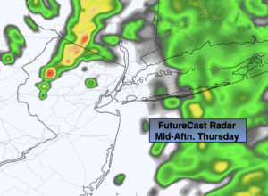
Today:
Cloudy with rain developing in the immediate NYC vicinity by afternoon. Rain will begin earlier over Long Island. To the West and South it will be mainly dry into midday with scattered showers developing during the afternoon. Highs in the 40s over Long Island to the lower 60s over Western NJ. Southeast to Northeast winds at 5mph.
Tonight:
Mostly cloudy. Lows in the lower 40s in the City, the upper 30s well inland. Northwest winds at 5-10mph.
Friday:
Sun and clouds during the morning, otherwise becoming mostly cloudy with spotty showers. Cool. Highs in the lower 50s.
Saturday:
Partly sunny. Highs in the upper 50s.
Sunday:
Partly sunny. Seasonal. Highs around 60º.
Monday:
Partly sunny. Highs in the lower 60s.