Synopsis:
It will be a raw start to the week with occasional showers and chilly readings. A weak frontal boundary to our South and an onshore flow will provide the area with the damp conditions. Highs will be more than ten degrees below average. The average high is 60º.
Scattered showers will continue tonight.
On Tuesday and Wednesday a weak ridge of high pressure will develop over the region. The atmosphere and ground for that matter will dry out. A mix of sun and clouds is expected with near seasonal readings Tuesday and mild readings for Wednesday.
The models continue with the idea of a storm affecting the region for late week. Rain is in the forecast for Thursday. The storm will slowly pull away on Friday. Showers will taper off during the day. This storm has an energetic upper level cold low. This will result in very chilly temperatures both Thursday and Friday.
Stay tuned.
Keep it here for a no nonsense, no hype forecast.
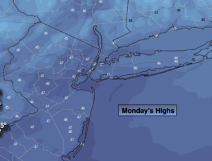
Today:
Cloudy with on and off showers. Chilly. Highs in the upper 40s. Northeast winds at 10-15mph.
Tonight:
Occasional showers. Lows in the lower 40s in the City, the upper 30s inland. Northeast wind at 8-12mph.
Tuesday:
Clouds to sun. Highs in the upper 50s.
Wednesday:
Partly sunny. Highs in the lower to mid 60s.
Thursday:
Chance of rain. Chilly. Highs in the upper 40s.
Friday:
Morning showers, remaining mostly cloudy. Chilly. Highs in the upper 40s.