Synopsis:
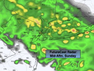
It’ll be a Sunday spoiler for the second half of the weekend. A warm front will work North into the Mid-Atlantic today. This will result in on and off rain throughout the day. Readings will be near the seasonal highs of the upper 50s.
Occasional showers will continue tonight.
Monday looks grey with on and off showers as the front weakens to our South. It’ll be chilly with the wind blowing off the cold Atlantic.
On Tuesday and Wednesday an upper level low will slowly move through the region. Spotty showers are likely on Tuesday. There will be dry times and some sun possible from time to time. Wednesday will be the best day of the bunch with the sun dominating the sky.
The models have done a complete 180 with the late week forecast. Guidance is showing a developing storm over the region. I have included the potential of rain for Thursday.
Sunday:
On and off rain. Highs in the upper 50s. East to Northeast winds at 5-10mph.
Tonight:
Occasional showers. Lows in the 40s throughout. Northeast wind at 8-12mph with gusts to 20mph along the coast.
Monday:
Cloudy with on and off showers. Chilly. Highs in the lower 50s.
Tuesday:
Clouds, some sun. Spotty shower. Highs in the upper 50s.
Wednesday:
Partly sunny. Highs in the lower 60s.
Thursday:
Mostly cloudy with a chance of rain. Highs in the upper 50s.