Synopsis:
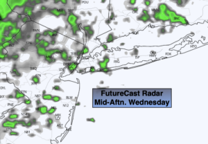
As we turn the calendar from March to April, a storm developing over Eastern Virginia will begin to affect our region. For today, any peeks morning sun will give way to scattered showers during the afternoon. Readings will be quite mild. On and off rain will continue Wednesday night as the low moves over the region. April’s debut on Thursday will start off wet. The low will pull up and off the coast during the day. Colder air will filter. Morning rain (there could be some wet snow well inland) will give way to afternoon sun. It will be chilly and windy.
Friday will feature mainly sunny skies, but despite the bright skies readings will be cold for April. Highs will only be in the mid 40s as cold air funnels in from Canada.
Typical early April conditions are expected for Easter Weekend. The sun will dominate Saturday. A mix of sun and clouds is expected for Easter Sunday.
Keep it here for a no nonsense, no hype forecast.
Today:
A bit of morning sun, otherwise thickening clouds. Scattered showers will develop during the afternoon. Mild. Highs in the lower to mid 60s. Cooler at the coast. South to Southeast winds at 5-10mph.
Tonight:
Periods of rain. Lows in the 40s. Southeast to Northwest winds increasing to 10-20mph by morning.
Thursday:
Morning rain (wet snow mixed in possible well inland). Afternoon sun. Windy and turning colder. Early highs around 50º.
Friday:
Partly sunny. Chilly. Highs in the mid 40s.
Saturday:
Mostly sunny. Milder. Highs in the mid to upper 50s.
Easter Sunday:
Partly sunny. Highs around 60º.