Synopsis:
Today will be a winner with abundant sunshine and mild readings as high pressure moves into the Atlantic. Highs away from the coast and cold Atlantic will be several degrees above the average high of the mid 50s.
Partly cloudy and mild conditions are expected overnight.
As we turn the calendar from March to April, a storm will affect the region. On Wednesday, any morning sun will give way to a wet afternoon. Readings will be quite mild. Rain will continue Wednesday night. April’s debut on Thursday will start off wet. The low will pull up and off the coast during the day. Morning rain will give way to afternoon sun. It will be chilly and windy.
Friday will feature mainly sunny skies, but despite the bright skies readings will be cold for April. Highs will only be in the mid 40s as cold air funnels in from Canada.
Typical early April conditions are expected for Easter Weekend. The sun will dominate.
Keep it here for a no nonsense, no hype forecast.
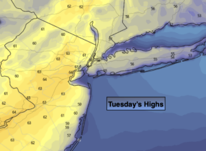
Today:
Sunny. Much milder. Highs in the lower to mid 60s just inland to the 50s along the coast. Southeast to South winds at 5-10mph.
Tonight:
Partly cloudy. Lows in the upper 40s in the City, near 40º inland. Southwest at 5mph.
Wednesday:
A bit of morning sun, otherwise thickening clouds. Rain will develop during the afternoon. Mild. Highs in the mid 60s. Cooler at the coast.
Thursday:
Morning rain. Afternoon sun. Windy and turning colder. Early highs in the lower to mid 50s.
Friday:
Partly sunny. Chilly. Highs in the mid 40s.
Saturday:
Mostly sunny. Milder. Highs in the mid to upper 50s.