Synopsis:
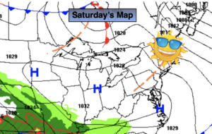
Our Spring Fling is over but its not like were going into the ice box. Temperatures will actually be near the average highs of the upper 40s. The sun will dominate this weekend as high pressure moves East from the Great Lakes
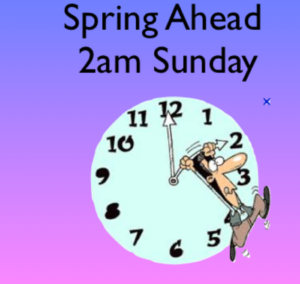
Tonight we “Spring Ahead”. Daylight Saving Time resumes at 2AM Sunday. Don’t forget to turn the clocks ahead one hour before hitting the sack tonight. We lose an hour of sleep BUT, the sun sets an hour later on Sunday. It’s also a good time to change the batteries in your smoke and carbon monoxide detectors.
Bright and chilly conditions are expected for Monday as another area of high pressure works in from the North.
A weak impulse will move out of the central Appalachians and toward the region on Tuesday. This system will be moisture starved. A mostly cloudy day expected with just the chance of a few showers.
The system will move off the coast on Wednesday. Morning clouds will give way to some afternoon sun.
Stay Tuned.
Keep it here for a no nonsense, no hype forecast.
Today:
Mostly sunny. Cooler. Highs around 50º. Northwest to West winds at 8-12mph.
Tonight:
Clear. Lows in the mid 30s along the coast, the upper 20s and lower 30s inland. West winds at 5mph.
Sunday:
Mostly sunny. Seasonal. Highs in the upper 40s.
Monday:
Partly sunny. Chilly. Highs in the lower 40s.
Tuesday:
Mostly cloudy with spotty showers possible. Highs in the lower 40s.
Wednesday:
Clouds to some sun. Highs around 50º.