Synopsis:
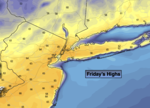
The Spring fling will continue for one more day. A weakening cool front moving through this morning bringing with it a few sprinkles, otherwise skies will become sunny. It’ll still be warm with readings in the 60s. The colder air is lagging behind the front about 150 miles.
Tonight the blast of cold air from the North will arrive on gusty Northwest winds. Readings will fall below freezing inland and remain just above along the coast.
The weekend will be cooler but bright with high pressure influencing our weather from Canada.
On Saturday night we “Spring Ahead”. Daylight Saving Time resumes at 2AM Sunday. Don’t forget to turn the clocks ahead one hour before hitting the sack Saturday night. We lose an hour of sleep BUT the sun sets an hour later on Sunday. It’s also a good time to change the batteries in your smoke and carbon monoxide detectors.
Bright and chilly conditions are expected for Monday.
The next chance of precipitation will be Tuesday. Weak low pressure will move out of the central Appalachians and toward the region. Light rain is likely. A bit of wet snow may occur, especially inland, at the onset but this will predominately be a rain event.
Stay Tuned.
Keep it here for a no nonsense, no hype forecast.
Today:
Spotty morning sprinkles, otherwise becoming sunny. Warm. Highs in the mid 60s. Northwest to West winds at 8-12mph.
Tonight:
Clear, colder and windy. Lows in the mid 30s along the coast, the upper 20s and lower 30s inland. Northwest winds increasing to 15-30mph with gusts to 40mph.
Saturday:
Partly sunny. Cooler. Highs around 50º.
Sunday:
Mostly sunny. Seasonal. Highs in the upper 40s.
Monday:
Partly sunny. Chilly. Highs in the lower 40s.
Tuesday:
Light rain is likely. A mix is possible at the onset, especially North and West. Highs in the lower 40s.