Synopsis:
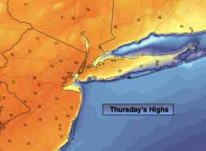
Near record high temperatures are possible today. Any morning fog or clouds will give way to mostly sunny skies. It will feel more like mid May then mid March. The wind will blow from the Southwest around an area of high pressure off the Mid-Atlantic coast. This will result in temperatures skyrocketing into the lower to mid 70s away from the immediate coast. The record high for Central Park for today is 73º set in 1977. It will be close. Coastal areas will be much colder with readings in the 50s and 60s due to the colder Atlantic influence. The map above tells the story.
A weakening cool front will move through during the day on Friday. Spotty sprinkles are possible during the morning. It’ll still be warm with readings in the 60s.
The weekend will be cooler but bright with high pressure influencing our weather from Canada.
Stay Tuned.
Keep it here for a no nonsense, no hype forecast.
Today:
Areas of morning fog and clouds, otherwise mostly sunny. May-like. Highs in the lower to mid 70s. Near record high temperatures. Much cooler along the coast. Southwest winds at 10-15mph.
Tonight:
Mostly cloudy. Very Mild. Lows in the lower to mid 50s along the coast, the 40s inland. Overnight readings will be warmer the average daytime high! Southwest winds at 5mph.
Friday:
Clouds and sun. Warm. Spotty morning sprinkles. Highs in the mid 60s.
Saturday:
Partly sunny. Cooler. Highs around 50º.
Sunday:
Mostly sunny. Seasonal. Highs in the upper 40s.
Monday:
Partly sunny. Chilly. Highs in the lower 40s.