Synopsis:
It’ll be clear tonight with most readings remaining above freezing by a few degrees.
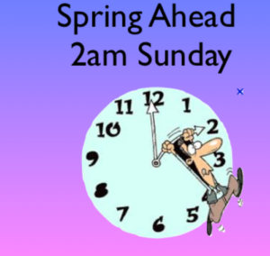
Tonight we “Spring Ahead”. Daylight Saving Time resumes at 2AM Sunday. Don’t forget to turn the clocks ahead one hour before hitting the sack tonight. We lose an hour of sleep BUT, the sun sets an hour later on Sunday. It’s also a good time to change the batteries in your smoke and carbon monoxide detectors.
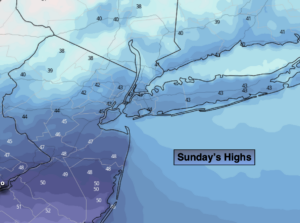
Sunday will be bright and Cool. A cold front will swing through during the afternoon with an increasing Northwest wind that will become strong. Gusts up to 45mph are likely later in the day. A stray snow shower is also possible by mid to late afternoon.
Sunny and chilly conditions are expected for Monday as another area of high pressure works in from the North.
A weak impulse will move out of the central Appalachians and toward the region later Tuesday. This system will be moisture starved. It now looks to be dry on Tuesday with a mix of sun and clouds. The impulse will move off the coast Tuesday night and Wednesday. Moisture from the East will result in increasing clouds. Light showers are possible Tuesday night and Wednesday morning. The sun should return later in the day.
A more signifiant area of low pressure will develop over the central Appalachians on Thursday and head into the Northeast. Rain is likely. At this time is setup is not there for any snow in our region.
Stay Tuned.
Keep it here for a no nonsense, no hype forecast.
Tonight:
Clear. Lows in the mid to upper 30s along the coast, the lower 30s inland. West winds at 5mph.
Sunday:
Mostly sunny and cool. Becoming windy during the afternoon. Highs in the mid 40s. Increasing Northwest winds at 15-25mph with gusts up to 45mph later in the day.
Monday:
Mostly sunny. Cold. Highs in the upper 30s.
Tuesday:
Sun and clouds. Highs in the lower 40s.
Wednesday:
Scattered morning showers. Some afternoon sun. Highs in the mid 40s.
Thursday:
Rain likely. Highs around 50º.