Synopsis:
Today will be bright and Cool. A cold front will swing through during the afternoon with an increasing Northwest wind that will become strong. Gusts up to 45mph are likely during the afternoon. Readings will be near seasonal averages in the upper 40s under mainly sunny skies.
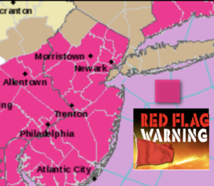
A Red Flag Warning has been issued for areas in fuchsia (map above). Dry ground, low humidity levels and strong winds will promote the growth of wild fires. Please use caution while outdoors while using flammables.
A short-lived Arctic blast will arrive tonight as Canadian high pressure moves in. Readings will drop to the teens and lower 20s. The wind will be like a slap in the face gusting up to 45mph. Wind chills will be in the near 0º well inland to the single digits and teens elsewhere.
Sunny and cold conditions are expected for Monday as high pressure moves overhead. Highs will be just above freezing, but thankfully the winds will have abated.
A weak impulse will move out of the central Appalachians and toward the region later Tuesday. This system will be moisture starved. It now looks to be dry on Tuesday with a mix of sun and clouds. The impulse will move off the coast Tuesday night and Wednesday. Moisture from the East will result in increasing clouds. Light showers are possible Tuesday night and Wednesday morning. The sun should return later in the day.
A more signifiant area of low pressure will develop over the central Appalachians on Thursday and head into the Northeast. Rain is likely. At this time is setup is not there for any snow in our region.
Stay Tuned.
Keep it here for a no nonsense, no hype forecast.
Today:
Mostly sunny and cool. Becoming windy during the afternoon. Highs in the upper 40s. Increasing Northwest winds at 15-25mph with gusts up to 45mph later in the day.
Tonight:
Clear, windy and very cold. Lows in the lower 20s along the coast, the teens inland. Northwest winds 15-25mph with gusts to 45mph early.
Monday:
Mostly sunny. Cold. Diminishing winds. Highs in the mid 30s.
Tuesday:
Sun and clouds. Highs in the lower 40s.
Wednesday:
Scattered morning showers. Some afternoon sun. Highs in the mid 40s.
Thursday:
Rain likely. Highs around 50º.