Synopsis:
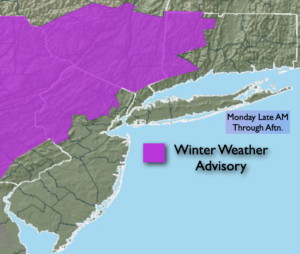
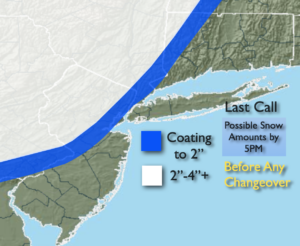
A rapidly moving weak low pressure system from the West and vigorous jet stream overhead will result in a period of wet snow inland and rain possibly mixed with a bit of snow at the coast. It will be a quick hitter. The timing looks to be late morning through mid afternoon. The precipitation will only last a few hours. It will be cold enough for wet snow inland. The snow may actually come down heavy for one or two hours at 1″ or more an hour inland. A quick few inches is possible North and West of I-95 with the jackpot zone being Northwestern NJ into Eastern PA (2nd map above). Along the coast and to the South mainly rain is expected, although a quick coating is not out of the question before changeover over the I-95 corridor.
Skies will clear tonight and most areas will be near or below freezing. A refreeze of slush and water is expected in many areas. Please use caution, especially around snow banks.
Quiet times will be with us for the rest of the week as another area of high pressure moves in. A mix of sun and clouds is expected. This will be a much deserved break from the recent snow and cold conditions. Readings will get near to above average by mid week. The average high is in the lower to mid 40s.
Stay Tuned.
Keep it here for a no nonsense, no hype forecast.
Today:
A quick hitting period wet snow inland. Rain mixed with a bit snow at the coast. Highs in the 30s. South to Southwest winds at 8-12mph.
Tonight:
Becoming mostly clear. Lows near freezing in the urban corridor, the 20s inland. West winds at 5-10mph.
Tuesday:
Partly sunny. Spotty shower or flurry (inland) possible Highs in the lower 40s.
Wednesday:
Mostly Sunny. Milder. Highs in the upper 40s.
Thursday:
Mostly sunny, seasonal. Highs in the lower to mid 40s.
Friday:
Sunny, colder. Highs in the upper 30s.