Synopsis:
High pressure will move to the East coast today. Sunshine, but chilly conditions are expected as most areas get above freezing.
Clouds will increase tonight. Once again, all readings will be at or below freezing. A refreeze of slush or water will occur. Please use caution, especially near snow banks.
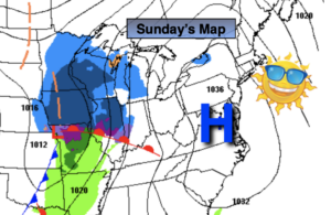
A rapidly moving weak low pressure system from the West and vigorous jet stream overhead will result in a period of wet snow inland and rain possibly mixed with a bit of snow at the coast. The timing looks to be around midday through the afternoon. The precipitation will only last a few hours. A light accumulation of snow is possible North and West. Think a coating to a couple of inches. (I’ll have a possible accumulations map, if need be, with the mid-afternoon update).
Quiet times will be with us for the rest of the week as another area of high pressure moves in. A mix of sun and clouds is expected. This will be a much deserved break from the recent snow and cold conditions. Readings will get near to above average by mid week. The average high is in the lower to mid 40s.
Stay Tuned.
Keep it here for a no nonsense, no hype forecast.
Today:
Sunny. Highs in the mid 30s. Northwest winds at 5-10mph.
Tonight:
Increasing clouds. Lows near freezing in the urban corridor, the teens and 20s inland. West to Southwest winds at 5mph.
Monday:
A period wet snow inland. Rain mixed with a bit snow at the coast. Highs in the upper 30s.
Tuesday:
Partly sunny. Highs around 40º.
Wednesday:
Mostly Sunny. Milder. Highs in the upper 40s.
Thursday:
Partly sunny, seasonal. Highs in the lower to mid 40s.