Synopsis:
Finally, a 36 hour period where I’m not using the “snow” word. It felt like we were in a snow globe and someone kept shaking it.
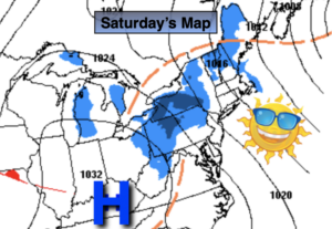
The weekend looks bright and chilly with high pressure moving in. Readings both today and Sunday will be in the mid 30s. A gusty wind will be the issue for Saturday. Sunday will be more tranquil. Lows tonight will be well below freezing. A refreeze of slush and standing water will occur. Please use caution.
A rapidly moving system from the Northwest and possible cyclogenesis off the coast will most likely result in a period of snow or snow mixed with rain on Monday. A light accumulation is possible North and West.
Quiet times will be with us for the rest of the week as another area of high pressure moves in. Readings will get near to above average by mid week. The average high is in the lower to mid 40s.
Stay Tuned.
Keep it here for a no nonsense, no hype forecast.
Saturday:
Partly sunny, breezy and cold. Highs in the mid 30s. Northwest winds at 10-20mph with higher gusts.
Tonight:
Mostly clear. Lows in the upper 20s in the urban corridor, the upper teens and 20s inland. Northwest winds at diminishing to 8-12mph.
Sunday:
Sunny. Highs in the mid 30s.
Monday:
A period snow or snow mixed with rain by midday. Highs in the upper 30s.
Tuesday:
Partly sunny. Highs around 40º.
Wednesday:
Mostly Sunny. Highs in the mid 40s.