Synopsis:
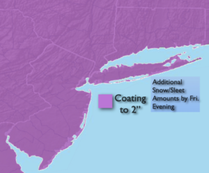
On and off light snow, sleet and freezing rain will will be with us today. A second weak impulse may enhance precipitation for a time. An additional coating to 2″ is possible in all areas through this evening. Needless to say, untreated walkways and streets will be slick.
The sluggish system will finally move off the coast this evening. Skies will become partly cloudy and readings in all areas will drop below freezing. A refreeze of slush and water is expected.
The weekend looks bright and chilly with high pressure moving in.
A rapidly moving system from the Northwest and possible cyclogenesis off the coast will most likely result in a period of snow or snow mixed with rain on Monday afternoon into the evening. As of this writing it doesn’t look like a big deal.
A mix of sun and clouds is expected Tuesday with readings a few degrees below the average high of 42º.
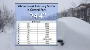
A factoid for you- As of Friday morning, Central Park snowfall of 24.4″ has made it to the 9th snowiest February on record. Records go back to 1869. Will we make the top 5?
Stay Tuned.
Keep it here for a no nonsense, no hype forecast.
Today:
On and off light snow or a mix. Highs in the 30º-35º. Northeast winds at 5-10mph.
Tonight:
Becoming partly cloudy. Lows in the 20s in the urban corridor, the upper teens inland. Northeast winds at 5-10mph.
Saturday:
Partly sunny. Cold. Highs in the mid 30s.
Sunday:
Sunny. Cold. Highs in the lower to mid 30s.
Monday:
Potential of a period snow or snow mixed with rain in the afternoon. Highs in the upper 30s.
Tuesday:
Partly sunny with near seasonal readings. Highs around 40º.