Synopsis:
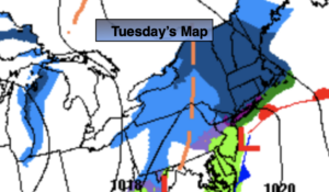
A weak low will move from West to East with a period of light snow today for the Northwestern suburbs and parts of the NYC vicinity. Mixed precipitation and rain is possible along the Southern Edge. Parts of Central and Southern NJ will receive little in the way of rain in the morning, but a bit of light rain is likely toward midday and afternoon.
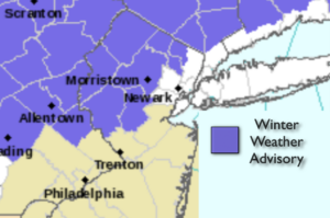
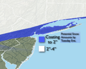
A Winter Weather Advisory is up for accumulating snow and ice for the Northwestern ‘burbs. Possible snow amounts are above.
We’ll get a brief break Wednesday as a quickly moving high pressure system moves in. It’ll be sunny with readings near freezing.
Arctic Air will be just to our North for the end of the week. At the same time the Southern jet stream will be riding up and off the coast with weak surface impulses moving through. The combination of these ingredients will give the parts region the likelihood for light snow Thursday. A light accumulation is possible, mainly South of NYC. The sun may return later in the afternoon. The second impulse will swing through for the first half of Friday. This system again looks more likely to affect Central and Southern regions of the tri-state with light snow. The Northern counties may not get into the action. The sun may return later in the afternoon on Friday.
This weekend should start off tranquil. I’m keeping Saturday snow-free at this time. The models are all over the place with a potential developing coastal storm. The threat is there for snow or a mix Saturday night into Valentine’s Day. This is by no way etched in stone.
Needless to say, we are in a very active pattern.
Stay Tuned.
Keep it here for a no nonsense, no hype forecast.
Today:
A period of snow is likely from the NYC vicinity and to the North and West. A mix will occur on the Southern fringe of the band of snow. Parts of Central and Southern NJ may not see much in the way of light rain until later in the morning into the early afternoon. Highs in the 30s. Northeast to Northwest winds at 5-10mph.
Tonight:
Clearing skies and cold. A refreeze of slush and water will occur. There will be icy spots in untreated areas. Lows in the mid 20s in the City, the teens inland. Northwest winds at 5-10mph.
Wednesday:
Mostly sunny, cold. Highs around 30º.
Thursday:
Light snow likely, mainly South of the City. Some afternoon sun. Highs around 30º.
Friday:
Potential of light snow mainly for Central and Southern areas. Some afternoon sun. Highs in the 20s to around 30º.
Saturday:
Mostly cloudy. Cold. Highs in the upper 20s.