Synopsis:
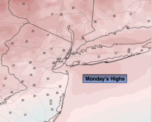
Bright and very cold conditions courtesy of high pressure will be the story for today. Highs will remain well below freezing.
Increasing and thickening clouds tonight. Light snow will develop late over the Northern half of the tri-state area.
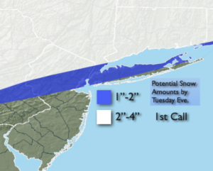
The weak low will move from West to East with a period of light snow for Tuesday. Mixed precipitation and rain is possible along the Southern Edge. Parts of Central and Southern NJ will receive little in the way of precipitation. A light accumulation is likely for the Northern half of the region. Possible snow amounts are above. These amounts will change some with new computer guidance coming in today.
We’ll get a brief break Wednesday as a quickly moving high pressure system moves in. It’ll be sunny with readings near freezing.
Arctic Air will be just to our North for the end of the week. At the same time the Southern jet stream will be riding up and off the coast. The combination of the two ingredients will give the region the potential for snow Thursday and the potential for light snow or a light mix Friday. The severity of this system is unknown at this time. Some of the models have the heavier precipitation staying just to our South. Please be aware that late week conditions maybe one of accumulating snow or ice.
Needless to say, we are in a very active pattern.
Stay Tuned.
Keep it here for a no nonsense, no hype forecast.
Today:
Mostly sunny. Very cold. Highs in the upper 20s. Northwest winds at 5mph.
Tonight:
Increasing and thickening clouds. Chance of light snow late for the Northern half of the region. Lows in the mid 20s in the City, the teens inland. Light and variable winds.
Tuesday:
A period of light snow possible or mix possible. Parts of Central and Southern NJ may not see much in the way of precipitaiton. Highs in the 30s.
Wednesday:
Mostly sunny, cold. Highs around 30º.
Thursday:
Potential of snow.. Highs around 30º.
Friday:
Potential of Light snow or a light mix. Highs around freezing.