Synopsis:
Cold high pressure will move in tonight. This will result in clearing skies and bitterly cold readings. Any standing water or slush will freeze solid.
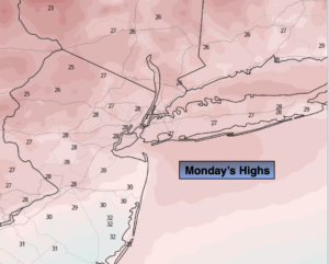
Bright and very cold conditions will greet us for Monday. Highs will remain well below freezing.
A low developing to our West will move our way Tuesday with a period of light snow or mixed precipitation. A light accumulation of snow is possible.
We’ll get a brief break Wednesday as a quickly moving high pressure system moves in. It’ll be sunny with readings near freezing.
Arctic Air will be just to our North for the end of the week. At the same time the Southern jet stream will be riding up and off the coast. The combination of the two ingredients will give the region the potential for snow Thursday and the potential for snow or a mix Friday. The severity of this system is unknown at this time. Please be aware that late week conditions maybe one of accumulating snow or ice.
Needless to say, we are in a very active pattern.
Stay Tuned.
Keep it here for a no nonsense, no hype forecast.
Tonight:
Clearing skies. Frigid. Lows around 20º in the City, the single digits and teens inland. Northwest winds at 8-12mph.
Monday:
Mostly sunny. Very cold. Highs in the upper 20s. Northwest winds at 5mph.
Tuesday:
A period of light snow possible or mix possible. Light accumulation li. Highs in the 30s.
Wednesday:
Mostly sunny, cold. Highs around 30º.
Thursday:
Potential of snow.. Highs around 30º.
Friday:
Potential of snow or a mix. Highs around freezing.