
Synopsis:
A storm developing off the North Carolina will move up and off our coast today. This should result in a moderate to signifiant snowfall on Super Bowl Sunday for most areas. The exception being areas to the North and West and along the South Jersey shore. The storm, unlike it’s predecessor is a quick hitter. The snow will begin around dawn or shortly thereafter. Rain may fall at the onset over parts of central and Southern NJ, but it will go over to snow. The snow will taper off from Southwest to Northeast during the afternoon. A period of heavy snow is possible for a couple hours either side of midday along and to the East of the I-95 corridor.
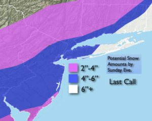
The last call snow amounts are posted. Yes, a plowable snow is expected for most with the jackpot amounts over Eastern Long Island and Southeastern Conncecticut. This area will be in the heaviest banding of snow pivoting around the storm. The amounts have been lowered North and West as this area will most likely be out of the heavier banding of precipitation.
Skies will clear tonight and all readings will be below freezing.
Bright and cold conditions will greet us for the beginning of the week.
Another system developing to our West will move our way Tuesday with a period of light snow or mixed precipitation.
Looking down the pike it could get quite active late week as Arctic air will be just to our North and plenty of moisture will be to our South. How this all plays remains to be seen.
Stay Tuned.
Keep it here for a no nonsense, no hype forecast.
Today:
Snow, possible heavy for a couple of hours along the I-95 corridor and to the East. Rain along the NJ coastal areas changing to snow. Snow tapers off during the afternoon. Highs in the 30s. Northeast to Northwest winds at 8-12mph.
Tonight:
Clearing skies. Cold. Lows in the mid 20sin the City, the teens inland. Northwest winds at 8-12mph.
Monday:
Mostly sunny.Colder. Highs around freezing.
Tuesday:
A period of light snow possible or mix possible. Highs in the 30s.
Wednesday:
Mostly sunny, cold. Highs around 30º.
Thursday:
Increasing clouds. Threat of late day snow. Highs around 30º.