

Synopsis:
The weekend will be a 50/50 split. Today will be the better half with abundant sunshine and mild readings as weak high pressure works in.
Clouds will increase tonight. All readings will be below freezing.
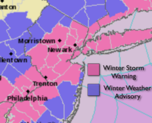
A storm developing over Eastern North Carolina will move up and off our coast tomorrow. This should result in a moderate to signifiant snowfall on Super Bowl Sunday for most areas. The exception being coastal NJ where it will start as rain and then switch to snow. This will keep amounts significantly lower. The storm, unlike it’s predecessor is a quick mover. The snow will begin around dawn Sunday and taper off by mid to late afternoon.
The 2nd call amounts are posted. Yes, a plowable snow is expected for most with the jackpot amounts in the NYC vicinity and to the North and East. This a possible amounts map and will change as the track of the storm is never 100% etched in stone.
Bright and cold conditions will greet us for the beginning of the week.
Another system developing to our Southwest will move our way with another threat of snow or a mix. Hang on!
Stay Tuned.
Keep it here for a no nonsense, no hype forecast.
Today:
Mostly sunny, breezy and mild. Highs in the mid 40s. West winds at 10-20mph.
Tonight:
Increasing clouds. Lows around 30º in the City, the 20s inland. West to Northeast winds at 5mph.
Sunday:
Snow, possible heavy at times. Rain along the NJ coastal areas changing to snow. Highs in the 30s.
Monday:
Mostly sunny.Colder. Highs around 30º.
Tuesday:
A period of light snow possible. Highs in the mid 30s.
Wednesday:
Mostly sunny, cold. Highs around 30º.