Synopsis:
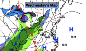
High pressure will move off the coast today (map above). Morning clouds and possibly a flurry in spots will give way to partly sunny skies. Readings will be seasonal-in the upper 30s.
Clouds will thicken tonight as a cool front approaches. Showers are possible before sunrise. Readings won’t be as cold as recent nights.
Early showers Thursday will give way to some sun as the front moves offshore. At the stroke of midnight New Year’s Eve it will be chilly but precipitation free. This break in the showers is the result of high pressure nosing in from Eastern Canada. New Year’s Day looks to start off with a bit of sun, but clouds will increase and thicken during the day. A warm front will move toward the region introducing the chance of rain and a bit of sleet later New Year’s Day. The rain will continue into the night and into the first part of Saturday. The sun should return during the day Saturday and it will be mild.
Another low pressure system may develop along the coast on Sunday. The potential is there for a period of rain. A mix is possible North and West. There is no Arctic high to work with this low. So it looks mainly wet and not white.
Stay Tuned.
Keep it here for a no nonsense, no hype forecast.
Today:
Clouds and sun. A spot flurry is possible mainly South and West this morning. Seasonal. Highs in the upper 30s. Southwest winds at 5-10mph.
Tonight:
Thickening clouds with scattered showers late. Lows around 40º in urban areas, the 30s inland. Southwest winds at 5-10mph.
New Year’s Eve:
Mostly cloudy during the morning with scattered showers. The clouds should give way to some sun. Highs in the mid 40s.
New Year’s Day:
Morning sun, otherwise thickening clouds with afternoon rain or a mix of rain and sleet. Highs around 40º.
Saturday:
Morning showers, otherwise becoming partly sunny. Mild. Highs in the mid 50s.
Sunday:
Mostly cloudy with the potential of a period of rain. A mix of rain and snow is possible inland. Highs around 40º.