Synopsis:
Morning rain will give way to a cloudy and drier afternoon as a cool front moves offshore. At the stroke of midnight New Year’s Eve it will be chilly but precipitation free with readings in the 30s to around 40º.
High pressure will move into New England New Year’s Day. This will result in a delay in the rain for the first day of 2021. Sun will greet us in the morning on January 1st, but clouds will increase and thicken during the day. A warm front will move toward the region introducing the chance of rain and a bit of sleet (North and West) later New Year’s Day (thinking from 3-6pm). The rain will continue into the night and into the first part of Saturday. The sun should return during the day Saturday and it will be mild.
Another low pressure system will develop along the coast on Sunday. The potential is there for a period of rain. A mix is possible North and West. There is no Arctic high to work with this low. So it looks mainly wet and not white. Any snow that potentially may accumulate, will occur over the higher elevations. Again, this looks to be minor.
Stay Tuned.
Keep it here for a no nonsense, no hype forecast.
New Year’s Eve:
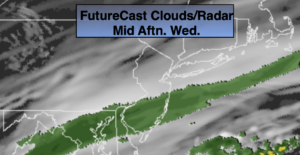
A period of morning rain, otherwise remaining mostly cloudy. Highs in the mid 40s. West to Northwest winds at 5-10mph.
Tonight:
Mostly clear and colder.. Lows around 30º in urban areas, the upper teens and 20s inland. Northwest to North winds at 5-10mph.
New Year’s Day:
Morning sun, otherwise thickening clouds with late afternoon rain developing. Most of the daylight hours will be dry. A mix of sleet and freezing rain is possible inland through early evening. Highs around 40º.
Saturday:
Morning showers, otherwise becoming partly sunny. Mild. Highs in the lower to mid 50s.
Sunday:
Mostly cloudy with a period of rain. A mix of rain and snow is possible inland. Highs in the lower to mid 40s, 30s inland.
Monday:
Clouds to sun. Highs in the mid 40s.