Synopsis:
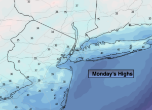
Temperatures will moderate today and reach near typical highs for this time of the year under mostly cloudy skies. The average high is 42º. Winter arrived at 5:02AM EST Monday.
A disturbance will race toward the region tonight from the Great Lakes. Scattered snow and or rain showers are likely.
Skies will become partly sunny on Tuesday with a gusty Northwest winds behind a strengthening Canadian Maritime storm.
Wednesday will be the best weather day out of the bunch with abundant sunshine and nearly calm winds as high pressure settles along the East coast. Highs will be a few degrees above average.
Christmas Eve will feature a developing deep Southerly flow ahead of a cold front and developing storm. Readings will pop into the 50s and showers are likely later in day. A shot of heavy rain and high winds are likely Late Christmas Eve into the wee hours of Christmas morning. It should dry out for Christmas Day with falling temperatures. It does not look like a White Christmas unless those of you that have deep snowpack will be able to keep it until Christmas morning.
Stay Tuned.
Keep it here for a no nonsense, no hype forecast.
Today:
Mostly cloudy. Highs in the 30s to around 40º. Northwest winds at 5mph.
Tonight:
Cloudy with scattered snow and rain showers. Lows around 35º in City, near 30º inland. West winds at 5mph.
Tuesday:
Party sunny. Breezy. Highs in the lower 40s.
Wednesday:
Sunny. Highs in the lower 40s.
Christmas Eve:
Mostly cloudy with scattered showers by evening. Balmy. Highs in the mid 50s.
Christmas Day:
Becoming partly sunny with falling daytime temperatures. Highs in the upper 40s during the morning. Readings will fall into the 30s by late day.