Synopsis:
Tonight will be the coldest night of the season so far. Skies will be clear and winds will go calm as strong high pressure moves right over the region. This will allow temperatures to plummet just outside of the City. Readings will fall into the teens and 20s.
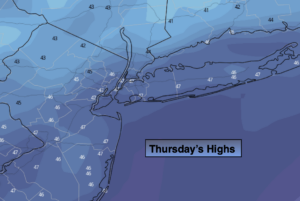
A slow rebound in temperatures will begin on Thursday as high pressure slips off the coast and a Southwest wind develops. The sun will dominate. By Friday, readings be several degrees above with a milder push of air. The average high temperature is 53º.
The weekend at this time looks decent. Another area of high pressure will move into Northern New England on Saturday. The cold air with this system will remain to our North but supply the region with abundant sunshine. It will be mild. Sunday will feature more clouds with readings just above average as moisture works in off the ocean.
There are no major storms in sight as we head into Thanksgiving week for the Northeast.
Stay Tuned.
Keep it here for a no nonsense, no hype forecast.
Tonight:
Clear and cold. Lows around 30º in urban areas, the teens and 20s inland. Northwest winds diminishing to below 5mph.
Thursday:
Mostly sunny. Chilly. Highs in the upper 40s. Southwest winds at 5-10mph.
Friday:
Mostly sunny. Milder. Highs in the upper 50s.
Saturday:
Mostly sunny. Mild. Highs around 60º.
Sunday:
Clouds, some sun. Highs in the mid 50s.
Monday:
Clouds, some sun. Scattered showers. Highs in the mid 50s.